


3.5 km | 5.3 km-effort
![Trail On foot Benešov nad Ploučnicí - [Ž] Benešov nad Ploučnicí - Huntířov - Photo](https://media.geolcdn.com/t/1900/400/bbcc4ada-53a6-4f1a-8a2a-532b77b1123c.jpeg&format=pjpeg&maxdim=2)

Tous les sentiers balisés d’Europe GUIDE+


FREE GPS app for hiking
 SityTrail
IGN / Geographical institutes
SityTrail World
The world is yours!
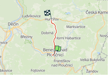
Trail On foot of 7.3 km to be discovered at Northwest, Ústecký kraj, Benešov nad Ploučnicí. This trail is proposed by SityTrail - itinéraires balisés pédestres.
Trail created by cz:KČT.
![Trail On foot Benešov nad Ploučnicí - [Ž] Benešov nad Ploučnicí - Huntířov - Photo 1](https://media.geolcdn.com/t/2048/auto/0b8b5081-2fd7-40f8-a0b6-f8814d579b21.jpeg&format=jpg&maxdim=0 "Trail On foot Benešov nad Ploučnicí - [Ž] Benešov nad Ploučnicí - Huntířov - Photo 1")
![Trail On foot Benešov nad Ploučnicí - [Ž] Benešov nad Ploučnicí - Huntířov - Photo 2](https://media.geolcdn.com/t/2048/auto/bacfd78f-c4f1-4c20-8f01-7aafbeecb7b7.jpeg&format=jpg&maxdim=0 "Trail On foot Benešov nad Ploučnicí - [Ž] Benešov nad Ploučnicí - Huntířov - Photo 2")
![Trail On foot Benešov nad Ploučnicí - [Ž] Benešov nad Ploučnicí - Huntířov - Photo 3](https://media.geolcdn.com/t/2048/auto/a87212e4-e366-427e-ba8d-ece34b186b5d.jpeg&format=jpg&maxdim=0 "Trail On foot Benešov nad Ploučnicí - [Ž] Benešov nad Ploučnicí - Huntířov - Photo 3")
![Trail On foot Benešov nad Ploučnicí - [Ž] Benešov nad Ploučnicí - Huntířov - Photo 4](https://media.geolcdn.com/t/2048/auto/48f34c19-eee0-49c9-9b95-e95856f2339e.jpeg&format=jpg&maxdim=0 "Trail On foot Benešov nad Ploučnicí - [Ž] Benešov nad Ploučnicí - Huntířov - Photo 4")
![Trail On foot Benešov nad Ploučnicí - [Ž] Benešov nad Ploučnicí - Huntířov - Photo 5](https://media.geolcdn.com/t/2048/auto/6be8e032-803d-4083-94f4-d91c6cc4d14c.jpeg&format=jpg&maxdim=0 "Trail On foot Benešov nad Ploučnicí - [Ž] Benešov nad Ploučnicí - Huntířov - Photo 5")
![Trail On foot Benešov nad Ploučnicí - [Ž] Benešov nad Ploučnicí - Huntířov - Photo 6](https://media.geolcdn.com/t/2048/auto/a80d60cb-bb30-40f6-b880-0f3b641241dd.jpeg&format=jpg&maxdim=0 "Trail On foot Benešov nad Ploučnicí - [Ž] Benešov nad Ploučnicí - Huntířov - Photo 6")
![Trail On foot Benešov nad Ploučnicí - [Ž] Benešov nad Ploučnicí - Huntířov - Photo 7](https://media.geolcdn.com/t/2048/auto/5c42610c-c72b-4109-b6cf-466aa803e3d8.jpeg&format=jpg&maxdim=0 "Trail On foot Benešov nad Ploučnicí - [Ž] Benešov nad Ploučnicí - Huntířov - Photo 7")
![Trail On foot Benešov nad Ploučnicí - [Ž] Benešov nad Ploučnicí - Huntířov - Photo 8](https://media.geolcdn.com/t/2048/auto/d2c4b9e5-0de2-4773-a61a-763a4eecd106.jpeg&format=jpg&maxdim=0 "Trail On foot Benešov nad Ploučnicí - [Ž] Benešov nad Ploučnicí - Huntířov - Photo 8")
![Trail On foot Benešov nad Ploučnicí - [Ž] Benešov nad Ploučnicí - Huntířov - Photo 9](https://media.geolcdn.com/t/2048/auto/bbcc4ada-53a6-4f1a-8a2a-532b77b1123c.jpeg&format=jpg&maxdim=0 "Trail On foot Benešov nad Ploučnicí - [Ž] Benešov nad Ploučnicí - Huntířov - Photo 9")
![Trail On foot Benešov nad Ploučnicí - [Ž] Benešov nad Ploučnicí - Huntířov - Photo 10](https://media.geolcdn.com/t/2048/auto/514fb4a1-cfc2-4a78-b741-63efae597f02.jpeg&format=jpg&maxdim=0 "Trail On foot Benešov nad Ploučnicí - [Ž] Benešov nad Ploučnicí - Huntířov - Photo 10")
![Trail On foot Tisá - [Z] Tisá (bus) – Ostrov - Photo](https://media.geolcdn.com/t/375/260/78f4b062-24a7-4483-95d6-be239bd66196.jpeg&format=jpg&maxdim=2)
On foot
On foot
![Trail On foot Ústí nad Labem - [Z] Sebuzín - Litoměřice - Photo](https://media.geolcdn.com/t/375/260/167dfb07-9404-4e35-a708-f0ca52d05b8b.jpeg&format=jpg&maxdim=2)
On foot
On foot
![Trail On foot Jetřichovice - [Z] Dolský mlýn - Pod Borovinou - Photo](https://media.geolcdn.com/t/375/260/cc7734bc-a1cb-44c1-a579-3999a7e367e8.jpeg&format=jpg&maxdim=2)
On foot
On foot
![Trail On foot Chřibská - [M] Chřibská - Rybniště (žst) - Photo](https://media.geolcdn.com/t/375/260/ec85bc98-2fdb-4814-b82a-0c53d51cc939.jpeg&format=jpg&maxdim=2)
On foot
![Trail On foot Huntířov - [Z] Oleška - Srbská Kamenice - Photo](https://media.geolcdn.com/t/375/260/b671590f-17dc-4f55-a338-c89d99bb2f15.jpeg&format=jpg&maxdim=2)
On foot
![Trail On foot Ústí nad Labem - [Z] Dobětice - Velké Chvojno - Photo](https://media.geolcdn.com/t/375/260/92f062a0-9eab-432b-8d79-33bfa2de2d0d.jpeg&format=jpg&maxdim=2)
On foot